Geoid and reference ellipsoids
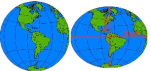
The earth is an oblate spheroid, with the minor axis 1/300th shorter than major axis.
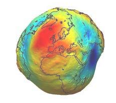
But the earth also has an irregular undulating surface that varies by +/- 75 m from the oblate spheroid.
source
So the geoid is the approximation for shape of earth at gravitational “sea level” that takes into account gravitational and rotational inconsistencies.
View a 3D version in Sketchfab.
This irregular shape is approximated for a projection using “ellispoids” with a major and minor axis that fit particular parts of the globe better than others. In the US, the North American Datum of 1927 (NAD 27) uses the Clarke66 (that’s 1866) ellipsoid, named for British geodesist Alexander Ross Clarke. He measured the meridian arcs in Europe, Russia, India, S. Africa and Peru (with chains and optical surveying instruments, traveling by horseback). His radii are 6,378,206.4 m and 6,356,583.8 m for the equatorial and polar axes, respectively. The NAD27 uses that shape with a fixed latitude and longitude at Meade’s Ranch, Kansas (39°13’26.686″ north latitude, 98° 32’30.506″ west longitude).
Open the project Properties/CRS box, and search for “NAD27” to view any projection based on that datum and to see its parameters.
In the era of satellites, we use earth-center datums and spheroids that can be used for the entire, bumpy globe (e.g., WGS84, GRS80). They work less well in specific areas, but do a better job overall with the globe.
Edited by NDB Jan 22, 2025 &DJH Jan 13, 2026