Adapted from Longley, Goodchild, Macguire, & Rind
How do we differentiate modeling from analysis? The two terms seem to go hand in hand…
Consider a spatial challenge – you are working for the city of LA, and you are tasked with estimating challenges to ordering city-wide evacuation sin the event of an emergency or natural disaster (think about the horrible fires earlier this year).
- If you are analyzing this problem, you might analyze the patterns of street intersections/directions and their overlap with population density. You will aim to map areas that might experience difficulty evacuating. This is an inherently static process, producing a single map or report planners can use
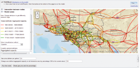
- In modeling, you may simulate the process of evacuation using what’s called on agent-based model (more on that later) coupled with spatial information. So your output will be dynamic, reflecting decisions and constraints you can continually update and revise. Below, you can see an example of one such possible model: a traffic model prepared by the University of Buffalo, that allows user to specify traffic parameters (i.e., gas prices) to simulate how that might impact evacuation practices.
So how do we answer this question?
Spatial analysis is static, spanning one point in time or an average through time. It leads you to search for patterns that may guide future hypothesis generation.
Spatial modeling will occur in multiple stages, perhaps across different points in time. In this case, you are trying to replicate real-world decision with implications for policy or environmental decisions. Output may not simply be a map, but an animation, a statistical artifact, or some other more abstract output.